Phil meets me at my door, and we walk in. Phil walks in every day; on this particular day he's detoured for a bit in the wrong direction to pick me up, so that I can learn the way in to the office and become somewhat oriented to Leicester.
My internal compass is working just fine; it's already acclimated to the northern hemisphere, and apparently moving 120 degrees east and 20 degrees further north isn't going to bother it much.
First landmark on our tour is the Leicester Royal Infirmary; conveniently close to home. Next time I'm royally infirm, I'll know exactly where to go. Then it's past the rugby ground (not to be confused with the football ground on the other side of Burnmoor St), a large park, and the prison.

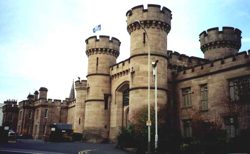
Leicester's prison is built to look like a castle. I don't know why; it's certainly not old enough to actually be a castle. It's set conveniently next to the park, and people can be seen walking past the base of the walls at pretty much any time of day or night, with no concern that they will be unexpectedly killed by escaping prisoners. I suspect this has to do with English politeness: if a prisoner accidentally knocked over a passer-by while escaping, he would probably stop, apologise, and help them up, before continuing to flee.
We cross the ring road. It's called a ring road because it goes around the town centre, so it's a ring in the conceptual, topological sense. It's certainly not a ring in the Euclidean geometric sense: it ducks and weaves all over the place. At this particular point, both directions of the ring road run side-by-side; but 20 metres in either direction it splits: to the south it goes either side of the rugby ground, and to the north, either side of some random office buildings and the Magazine.
The Magazine was once the gateway to The Newarke ("the new work", because when they built it it was, well, new). It was used as a magazine for storing armaments during the English Civil War, which is where it aquired its current name. It is now orphaned by the ring road from the area to which it used to be a gate, and sits isolated, rather like the Barracks Arch in Perth.
A little further on is the headquarters of the city council, built in an architectural style I call Civic 70's, but which most people would just call ugly. Then past a nightclub called the Lizard Lounge, which is in what appears to be a Tudor building: dark wooden beams with white paneling between. I have no idea if it is genuine.

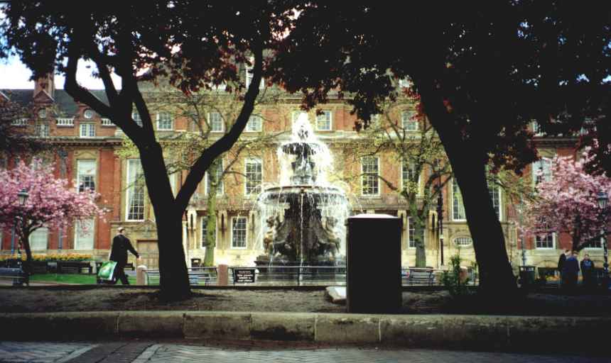
Then it's the town hall and town square. The town hall was built in about 1876, and the square presumably the same. The square contains a fountain, some nice flower beds full of tulips, and a bunch of cherry blossom trees. Some bureaucratically minded individual has caused to be placed a sign on the low railing around the fountain: "Warning: water presents a danger to children." This seems somewhat inconsistent: why not also signs saying, "Vehicles present a danger to the arrangement of your internal organs", "Giant asteroids present a danger to dinosaurs", "Stupid bureaucracies present a danger to your mental health".
On the south side of the square is Horsefair street, so named because horses were sold in the adjoining fields in the late 15th century.
Many of the names of the older streets, of course, reflect their history. For example, Leicester used to be a walled town, and several of the roads near the town centre are named "Gate": the Megazone office is on Belgrave Gate; there's another road named Church Gate, and the pedestrian mall we're about to walk up is charmingly named Gallowtree Gate. Interestingly, these roads are not named after the gates they led to; the gates to the town had boring names like "North Gate" and "South Gate". The roads called "Gate" actually followed along the town walls, on the outside. These roads are now in the centre of town because the town centre has crawled to the east over the centuries.
On the east side of the town hall square is Every Street. I have no idea how it came by this name.
The pedestrian mall is reminiscent of the Hay Street and Bourke Street malls. A short walk over from it is the Leicester markets. A sign tells me that there were markets in Leicester 700 years ago, and a map of old Leicester shows the "Saturday Markets" in this location; but I don't know if they have been in continuous operation for all that time. Six days a week, the market sets up at about 8am and is empty again by nightfall.
The mall leads to the clock tower, which dates from 1868. A couple of other malls lead off from this one, and ahead is a road called Haymarket, which becomes Belgrave Gate. This part of Belgrave Gate has bus stops all along one side, and a taxi rank along the other. The actual driveable space down the middle of the road is approximately one lane wide.
Buses come in three sizes: sawn-off (which is about half the length of a regular bus), regular, and double. The double-decker buses look quite preposterous on some of Leicester's narrower streets; they give the impression of being wider than the street they are being driven down.

The taxis all look old. They look like they were designed fifty years ago; and this is largely because they were. For some reason, probably to do with some kind of protectionist law, taxis are manufactured by specialty companies, who having no competition are under no pressure to update their designs. So they are all black, and built liked curved bricks. They bear signs on the back pronouncing them to be "licensed hackney carriages".
Up Belgrave Gate; past the roundabout. They're very keen on roundabouts in England; there's another one a little further up the road where Belgrave gate meets the ring road. This is because roundabouts deal well with roads meeting in numbers other than four, and at angles other than 90 degrees; circumstances which occur frequently in England. They're often the scary two-lane kind of roundabout like they have in Melbourne; but the one at the ring road is a special hyper-scary type: there is a fly-over across the middle of the roundabout for traffic that wants to continue around the ring, with the three-lane roundabout itself for traffic that wants to get on or off.
Across the road from Megazone is the Ring Cafe, which is for some reason universally referred to as the Ring Caf. (The "Ring" part comes from its proximity to the ring road.) The Ring Caf is open from 7:30am to 3pm. This is typical of many businesses in the UK: they're open 8 or 8.5 hours a day, 5 or 6 days a week, because there's only one shift of people that work there. Right next door is Attiq Fast Foods, who are open 3pm to 11pm; apparently the idea of forming one larger business with two shifts has never occured.
Three people work at the Ring Caf: an asian couple (who I'm sure own the business and live above it), plus a side-kick. There are four tables, one of which is the non-smoking section. This is unusual: most places in the UK don't even have a non-smoking section.
If you dine in, they serve your food on real plates, and give you real metal knives and forks. Dine-in tea or coffee is in real coffee mugs. Some of the coffee mugs are plain, but some have the sort of artwork on them that you'd expect to see on a coffee mug in a home or office: Garfields, advertising slogans, etc.
They're very keen on knives and forks in the UK. When I order a cheese burger and chips at the Ring Caf, they give me a knife and fork to eat it with. And they do this even if I order take-away (translation for Americans: "to go"): they give me a metal knife and fork, and expect me to bring them back next time.
This knife and fork keen-ness causes certain other oddities: in the freezer aisle at the Safeway supermarket, I come across a baked bean pizza. The mind boggles.
Much of the really old part of Leicester is in a part of the city called Castle Park. It's not actually a park: it's just a bunch of streets with a bunch of buildings, some of which happen to be old.
The oldest are the Roman ruins. The Romans were apparently the first people to build a town here, nearly 2000 years ago, and the surviving ruins are of the health club, including baths, dating from about 150AD. Most of the ruins are foundations and stubs of walls, only about 0.5 metres high; but there is a single sizeable fragment of wall surving, named "The Jewry Wall (origin of name unclear)". There is a sign explaining details about the ruins, which politely says, "This building was ancient before your continent was even a gleam in a cartographer's eye."
Somewhat less old is the castle motte, or mound. This is a largely artificial hillock, just large enough for a wooden curtain wall and extremely small wooden keep. Down one side of the mound was a covered wooden walkway, leading to a wooden-walled bailey or courtyard at the bottom, containing a number of ancillary buildings. Around both the mound and the bailey was a ditch, filled with water from the nearby River Soar. This was all caused to be built by William the Conqueror shortly after 1066, in order to let the locals know who was boss.
Nine hundred years later, none of the wooden structure remains. Many of the buildings and the wall of the bailey were gradually replaced with stone, much of which does still exist; but there is nothing but flat ground on the top of the mound, and the remaining stone buildings and wall do not form a secure area.
The Soar used to have meandering edges. Eventually, it was canalised: put into a straight, narrow, deep hard-sided bed. The space between the mound and the river, formerly full of shallow twisty turny channel filled with rushes, was turned into Castle Gardens, a public park.
The canalisation of the Soar connected Leicester to the rest of the canal system, and therefore to the industrial revolution. Leicester was a late joiner, but the new canal allowed the cheap import of coal, and the cheap export of textiles. Leicester became a centre of weaving and clothing manufacture.

You can walk along the edges of the canal: on the far side, there's a footpath right along the edge, going underneath each of the frequent bridges. There are occasional rowers, and many water birds, particularly white swans. At the last bridge before I have to step back up to road level to cross to Burnmoor St, there lives a black swan. It's a long way from home.